Our Technology
Open Zoning's platform represents our effort to make zoning data meaningful and development-oriented. We transform zoning interactions into accessible experiences through maps, diagrams, and visual graphics, overcoming the zoning literacy barrier.
The functionalities include:

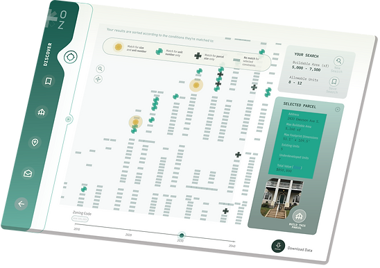
Discover
Discover zoning dynamics across
lots, neighborhoods, and time

Build
See what’s possible to build
on a lot in mere moments

Contribute
Add to our growing database of
machine-readable zoning data
Our platform also brings together zoning resources that were once scattered within web pages across both city and county websites. By both eliminating the zoning literacy barrier and centralizing the needed zoning resources, Open Zoning’s platform radically creates new accessibility to zoning information.

Try Our Demo!
Use the Open Zoning platform to instantly assess development feasibility for entire neighborhoods or cities.
Open Zoning utilizes the power of zoning data, enabling users to visually analyze what is possible to build on a parcel at the neighborhood level. This system operates in three major steps: Data Input, Technology Stack, and Applications.
Data Inputs
Open Zoning is creating an open-source zoning database, incorporating resources from the National Zoning Atlas and contributions from municipalities, researchers, and citizens

National Zoning Atlas

Open Source Data
→
Technology Stack
→
Applications
The core is its unique technology stack, anchored by the Open Zoning Feed Specification (OZFS). With the help of our unique data processing engines, OZFS converts complex zoning data into machine-readable formats, standardizing and simplifying access to zoning information
Open Zoning
Feed Specification
District Intersection Engine
Zoning Translation
Engine
Spatial Engine
Open Zoning Feed Specification (OZFS) enables nationwide zoning accessibility via the Open Zoning Platform, which offers detailed maps and diagrams. Our API allows real-time integration of this data into various research projects and products

API

Open Zoning
Platform
OZFS + Open-source
The Open Zoning's primary insight is that zoning data must be machine-readable to be universally accessible and actionable.
This led to the development of the Open Zoning Feed Specification (OZFS), a unique national standard for such data.
The OZFS serves as a guide to convert city zoning information from inaccessible documents into computer-queryable files.

Engines
Development happens on a lot-by-lot basis. Open Zoning believes that to make zoning information truly legible and actionable for everyone, it must be decoded at the lot level and turned into build information such as maximum height and allowable footprint.
To accomplish this level of accessibility, Open Zoning has developed three engines that allow us to decode zoning at the lot level. The result is the novel possibility to not only instantly query zoning information at the parcel level, but to instantly query build information.

Engine 1:
The District Intersection
Uses zoning district and parcel boundaries to determine which zoning districts a parcel lies within.

Engine 2:
The Zoning Translation
Open Zoning's engine intakes district data from the District Intersection Engine, interprets property zoning codes, and converts them into specific build constraints and regulations.
It centralizes geographic data and reconnects zoning aspects via an algorithm that calculates allowed housing units based on parcel information.
This allows unprecedented open analysis of zoning-allowed housing units across municipalities, enabling calculations of location, size, and quantity of permitted housing units in areas, neighborhoods, or cities.

Engine 3:
The Spatial Information
Translates the Zoning Translation Engine’s output into spatial information, driving our platform’s map-based and 3d visualizations.

API
Once a feed and it’s files have been created for a municipality and information has begun being entered into those files, anyone can download this information from our Github repository or make calls to our API, requesting municipality zoning information in real time.
This allows anyone to instantly and seamlessly integrate our data into their work.